
Even now, it seems bizarre labelling the scene of what is variously described as a "disaster" and a "massacre" as a "set", borrowing the language of the theatre and film-making. But, since it is our contention that the site was turned into precisely that, a film-set for the benefit of both Hezbolla and the media - in the finest tradition of "Pallywood" - we will keep to this description.
As we noted in the introduction, though, the "set" is in the hamlet of Khuraybah, roughly one mile north of the village of Qana and about eight miles south-east of the port town of Tyre on the Lebanese coast. The above is a satellite image marked with some of the key areas that played an important part of the staged drama (double-click the image to enlarge).
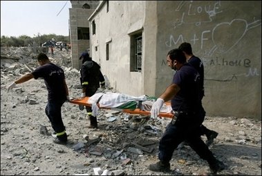
 Apart from aiding the narrative and the understanding of the reader, one of the reasons why it is so necessary to describe this "set" in some detail is to counter the wholly misleading information conveyed by the published photographs and their captions. Typifying the problem is this picture which appeared on the front page of The Daily Telegraph on the morning of 31 July. It shows the iconic figure of "White Tee-shirt" and the caption reads:
A rescue worker carries the body of a young girl from the ruins of the basement shelter where at least 57 Lebanese civilians, mostly children, were killed by an Israeli air strike on the village of Qana yesterday.It is ironic that the web news editor of this newspaper has been amongst the most voluble critics of the claimed failures of this blog to carry out "fact-checking", yet much of the confusion in the early stages arose from demonstrably false statements such as this, in his own newspaper.
Any ordinary person unfamiliar with the details of the site would assume that the "rescue worker" had just emerged from the wreck of the basement shelter, and that the debris in the background was part of the wreckage. Only later did we fully realise that the "White Tee-shirt" is some 400 yards away and that the wreckage in the background is from a completely different building, destroyed in a previous air strike.
Once we realised this, the pieces started to fall into shape. With the additional detail that we have been able to find (and have been sent) we have been able to put together an analyses of how this and the equally iconic "Green Helmet" scenes were staged. The crucial points are the wrecked house itself, the assembly area for the bodies, outside the house, the "staging area" about 100 yards or so from it, and then the most important part of the "set", the piece of road we call "Stretcher Alley". In the following sections, we have a look at each.
The wrecked house
 Curiously, for an incident that was so intensively photographed, there have been few clear pictures of the wrecked house actually published. Where shots have been taken, it seems that most of the photographers could not resist posing one or other figures in front of the building, presumably to give their creations a human dimension. Perhaps the best image comes from AFP, which, if we have located it correctly, seems to show the south-west face of the partially collapsed building, the opposite site from where the casualties were extracted.
 From the satellite image, the main entrance to house itself, and therefore the front, seems to be orientated roughly south-west. This image (right) shows that face, the remains of what we are told was a three storey house, the three floors presumably including the so-called basement. The entrance and exit to the basement, used by the rescuers, is round the corner to the left in this view, on the north-west face, at which a UN excavator can be seen working.
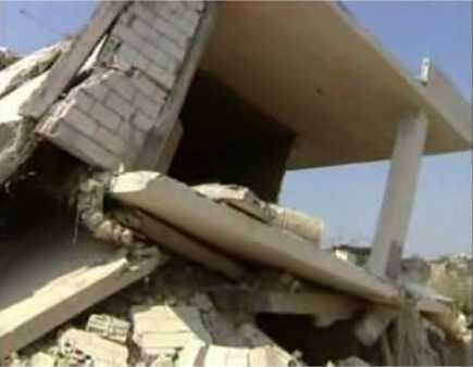 In this frame, a video grab from the Channel 4 News footage, we see the upper part of the north-west face of the building, below which is the main entrance and exit to the basement area, just visible at the lower part of the picture. The top floor structure looks largely intact, with the central section walls having collapsed, dropping the top section onto the basement structure.
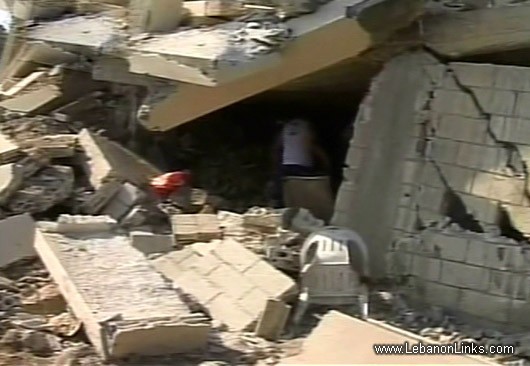 This is the lower part of the north-west face, showing the entrance and exit to the basement area where most of the bodies were found. The canted, fractured beam at the front is the edge of the floor slab to the upper floor, which is restricting access to the room. There is an un-made road in front of this and (behind the viewer, unseen) is a steep drop, much of the higher part being littered with wreckage.
 Entering the basement, this is a view from right to left (with the entrance to the rear), showing the debris in the room. As can be seen, the structure is largely intact, but for the collapse of the left-hand wall (which is to the rear of the house), giving rise to a landslide effect. The debris is said to have smothered casualties rather than crushed them, which explains their lack of visible injury.
 This view of the same room gives a better view of the structural condition and the scale of the debris slide - although some debris has probably been removed by the time this photograph was taken. Curiously, in the early frames of the rescue, many of the bodies are seen in the area where the group of men is standing, on top of the debris.
 And this is a rare shot of the right-hand wall of the room, showing something that is hinted at in the previous frame by a glimmer of light in the general location. This is the second entrance to the room - possibly a doorway - which leads out to the front of the house (although the opening is not visible in the shot showing that face). Whether this opening played any function in the rescue/recovery is not known.
 Continuing the "virtual tour" of the exterior, this looks to be the north-east face of the building, the side where the basement wall collapse and from which the debris slide entered the room.
This, therefore, is - presumably - the face exposed to the blast which precipitated the collapse, which presents something of a mystery. The figure to the right is standing with a group of others (unseen) on the veranda of a neighbouring house, the structure of which looks largely intact, although glazing seems to be absent. The veranda and that house is better seen in the next frame (below).
 This frame shows the eastern quadrant of the south-east face, revealing the extensive partial collapse of the roof and the almost complete collapse of the middle floor structure. To the right is the veranda referred to in the previous frame, and the almost intact adjoining building. To the left, out of shot, is the front of the house, shown in the second frame of this sequence. This completes the "tour".
The assembly area
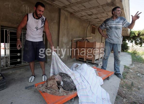
 The next key area is the assembly area. This is the ground to the right of the main basement entrance/exit (as you face it), where bodies extracted from the wreckage were first laid out. At times - as in this frame - they were covered - at other times they were not. Throughout the period of recovery, a variety of people were photographed against this backcloth, this frame showing a character in a pale green shirt, described as a "local resident". He appears in many more frames.
According to one witness, from here the bodies were transported directly to the waiting ambulances. But this was not always the case. We aver that the assembly area served another function, that of a selection area. Bodies (and survivors) with the potential to use for staged photo-opportunities, were chosen here and sent to an intermediate "staging area", about 100 yards or so from the wrecked building. There, they were held as "props" while photo-shoots were organised.
The staging area
 This, then, is the "staging area" seen in a still photograph from Getty Images, taken by Anwar Amro. It has a veranda structure in front of what appears on the satellite photograph to be a substantial building, the function of which is unknown. The view in this frame is in the direction of the route to the wrecked building. Much of the action takes place in the further end of the veranda, where the vegetation can be seen.
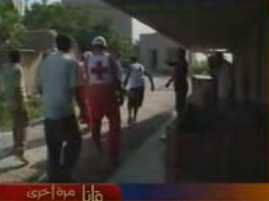 This is the same area, but taken in the opposite direction, towards "Stretcher Alley". The same box-like structure can be seen, this time in the centre foreground, with a stretcher party just embarking on its journey to the waiting ambulances. The figure under the veranda, just to the right of centre in the frame, is evidently giving directions to the party.
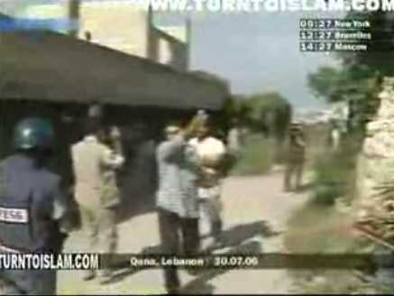 This is an external view of the same building, again looking in the general direction of the wrecked building. This particular scene shows "White Tee-shirt" setting off on his "camera run", of which we will see more in Part 6.
Evident from this view is the considerable size of the building, suggesting industrial usage or warehousing.
Stretcher Alley
 From the "staging area" the next significant location is "Stretcher Alley", some 200 or so yards further one. It is approached via a convoluted route, the final phase of which culminates in a sharp right hand turn, which we call "Stretcher Corner". It is illustrated here in a photograph (left) published by AFP, showing the alley from the lower end, with a stretcher being carried round the corner onto the alley itself. Up the rise, at the end, you can see the area where ambulances and media vehicles are parked.
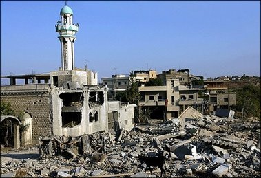
 This second view, sideways on, is about halfway up the alley, again showing a stretcher party making laborious progress up the rise. What is clearly evident is the ruined mosque and jumble of wreckage and debris from previous bombing, which obstructs the progress of vehicles - hence, we are told, necessitating the carriage of casualties.
It has to be stressed that it is only this section which impedes access. Beyond this, right up to the site of the wrecked house, there is a clear roadway, the width more than adequate to take ambulances and even heavier traffic. Beyond this section, up to the ambulance waiting area, the road is also relatively clear. Furthermore, this is not heavy debris but largely lightweight building blocks originating from the collapsed wall of the mosque alongside.
 From this view, we see "Stretcher Alley" taken from the top end, the vantage point slightly below and to the right of the parking area. Again very evident is the jumble of wreckage, but the top end of the road (just visible) looks quite clear. At that end is what appears to be the wreckage of a car or some other vehicle and, at the lower end, you can see the corner building, from round which the casualties and their bearers emerge.
 And this is what it is all about: this stage of the route becomes a vantage point for the media - a clear line of sight and an impressive backcloth of wreckage against which to frame photographs. In this picture, the journalists can be seen corralled together in one spot, awaiting their next photo-opportunity. For other shots, they congregated on the left, just up from the ruined mosque.
But for the blockage on "Stretcher Alley", ambulances would have been able to travel virtually to the scene of the wrecked building. One effect of that, however, would have been to deny major photography opportunities.
Nick Blanford, working in Lebanon for twelve years for The Times and Time magazine, and one of the first on the spot says, is cited in Stern magazine (translation here) saying that "the ambulance (singular) had no chance to get to the destroyed building." Thus, he claims that the rescue workers had to carry the bodies over a distance of 500 metres. "That's the reason there are so many pictures of rescue workers with children in their arms," he claims.
For want of definitive, authoritative answers, the most obvious conclusion is that it suited both the journalists and Hezbolla to keep "Stretcher Alley" blocked to vehicular traffic, precisely because its continued closure maximised the photo-opportunities. By this means, it became a grotesque film set, exploited by a cast of actors parading their "props" - the bodies of children - for mutual benefit of both audience and players.
However, there may be an even greater mystery to the saga of the blockage, as satellite maps indicate that there was an alternative route, which by-passed "Stretcher Alley" altogether. We deal with the implications of this in Appendix 1.
back to the contents page
COMMENT THREAD
No comments:
Post a Comment
Note: only a member of this blog may post a comment.